Hikers of Ventura County, rejoice! A new and exciting addition to the Conejo hiking trails just went into place and will be open to the public soon! Conejo Open Space has installed a new bridge linking the Wildwood trail system to the Conejo Canyons trails. Having hiked every foot of trail in Wildwood, I'm excited to try out a new area. I have never hiked the Conejo Canyons, but have seen trails in the hills and wondered how to access them. Now, once this bridge is open to the public, I can access it through my own backyard, Wildwood!
In other news, my poor trail blog has been so neglected. After our big trip to Mt. Langley, I started two new jobs along with seminary, so my time quickly disappeared. Lately, I have also had some health trouble that has limited my hiking. Hopefully, I can work on those trails that I know by heart until I can get myself back into shape and try out some new trails. Until then, keep hiking!
Monday, October 24, 2011
Monday, July 26, 2010
Simi Peak via Lang Ranch
Distance: 9 miles
Elevation +/-: ~1300'+
Hike Time: 3:00 (I think)
Rating: Difficult
How to get there:
The trailhead is in Lang Ranch, near the intersection of Avenida de los Arboles and Westlake Blvd. From Westlake Blvd. turn on Lang Ranch Pkwy. Take Lang Ranch past the Chumash Center until it makes a sharp right turn. The trailhead is on your right. There is also a walking trail on the right side of the road that leads straight to the trailhead, so you could park anywhere along Lang Ranch Pkwy.
The Trail:
This Saturday, I tried out a new trail. I had tried to hike Simi Peak a few years ago from a different trailhead, but it wound up being a very hot day and we got off on the wrong trail or something. We eventually gave up and got some Jamba Juice on our way home. This time I did actually make the peak, though not without incident. (more on that later)
Simi Peak is the highest point in the hills between the Conejo Valley, Simi Valley and the San Fernando Valley, topping out at 2403'. There are several ways to reach it, most of them being in the Westlake Village area on the north side of Kanan Rd. This particular trail, though starts out in Lang Ranch near the Chumash Center. I have hiked through some of the Oakbrook Regional Park south of the Chumash Center, but had never realized how much hiking there is on the north side in the Lang Ranch area.
Much of the trail is on the Albertson Motorway, which is an emergency access road. This means that it is very wide and well graded, making it great for hiking, biking and horseback riding. Which also means you need to be aware that those other people will be around. The first 1.5 miles of the trail are very easy. The motorway skirts the edge of the Chumash Center grounds and makes for a nice hike. A little over half a mile in, the road goes into private land, so you are ushered onto a scenic detour trail that is quite beautiful in spots.
Soon the trail meets back up with Albertson Motorway and the hiking gets much harder. To this point you have gained roughly 300' in elevation over 1.5 miles. From here you will gain nearly double that (more than 500') in the next 1.5 miles, and because it is an emergency road, it is steeply graded with no switchbacks. There is also very little shade, so take your breaks when you can. This is not the prettiest part of the trail, but there are some great views as you climb quickly to the tops of the ridges.
Soon you reach a gate that marks the Thousand Oaks city boundary where you cross into National Park Open Space. Not long after crossing into the NPS area you turn off the motorway onto a trail marked Palo Comado, China Flat, Simi Peak. You'll have to keep an eye out for this trail because it is way off to the right as you reach a large graded area on top on one of the ridges, almost hidden by bushes.
Once on the Palo Comado, China Flat, Simi Peak trail (wow, that's a mouthful), the hiking gets much easier and very picturesque. As you drop into the China Flat area, that landscape suddenly turns to the beautiful oak groves and meadows that made this area such popular ranching land before suburbia took over. Soon after, you leave the Palo Comado Trail and head out onto China Flat.

You wander through this beautiful area for about half a mile before turning right onto the Simi Peak trail.
 Now the bushwhacking begins! The trails are much narrower and more overgrown from here on out, so be ready to push through some brush. The trail continues on through more meadow land for another half mile, then begins the final ascent to the peak. Of course, you have to go down before you go up, but it isn't long before you are standing on the top. Take a look:


Elevation +/-: ~1300'+
Hike Time: 3:00 (I think)
Rating: Difficult
How to get there:
The trailhead is in Lang Ranch, near the intersection of Avenida de los Arboles and Westlake Blvd. From Westlake Blvd. turn on Lang Ranch Pkwy. Take Lang Ranch past the Chumash Center until it makes a sharp right turn. The trailhead is on your right. There is also a walking trail on the right side of the road that leads straight to the trailhead, so you could park anywhere along Lang Ranch Pkwy.
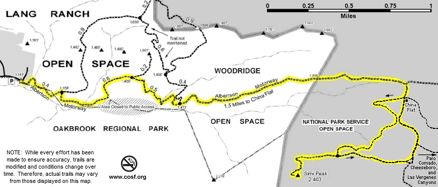 |
| The trail map, though I didn't take the right turn at China Flat like this map shows. |
This Saturday, I tried out a new trail. I had tried to hike Simi Peak a few years ago from a different trailhead, but it wound up being a very hot day and we got off on the wrong trail or something. We eventually gave up and got some Jamba Juice on our way home. This time I did actually make the peak, though not without incident. (more on that later)
Simi Peak is the highest point in the hills between the Conejo Valley, Simi Valley and the San Fernando Valley, topping out at 2403'. There are several ways to reach it, most of them being in the Westlake Village area on the north side of Kanan Rd. This particular trail, though starts out in Lang Ranch near the Chumash Center. I have hiked through some of the Oakbrook Regional Park south of the Chumash Center, but had never realized how much hiking there is on the north side in the Lang Ranch area.
Much of the trail is on the Albertson Motorway, which is an emergency access road. This means that it is very wide and well graded, making it great for hiking, biking and horseback riding. Which also means you need to be aware that those other people will be around. The first 1.5 miles of the trail are very easy. The motorway skirts the edge of the Chumash Center grounds and makes for a nice hike. A little over half a mile in, the road goes into private land, so you are ushered onto a scenic detour trail that is quite beautiful in spots.
Soon the trail meets back up with Albertson Motorway and the hiking gets much harder. To this point you have gained roughly 300' in elevation over 1.5 miles. From here you will gain nearly double that (more than 500') in the next 1.5 miles, and because it is an emergency road, it is steeply graded with no switchbacks. There is also very little shade, so take your breaks when you can. This is not the prettiest part of the trail, but there are some great views as you climb quickly to the tops of the ridges.
Soon you reach a gate that marks the Thousand Oaks city boundary where you cross into National Park Open Space. Not long after crossing into the NPS area you turn off the motorway onto a trail marked Palo Comado, China Flat, Simi Peak. You'll have to keep an eye out for this trail because it is way off to the right as you reach a large graded area on top on one of the ridges, almost hidden by bushes.
Once on the Palo Comado, China Flat, Simi Peak trail (wow, that's a mouthful), the hiking gets much easier and very picturesque. As you drop into the China Flat area, that landscape suddenly turns to the beautiful oak groves and meadows that made this area such popular ranching land before suburbia took over. Soon after, you leave the Palo Comado Trail and head out onto China Flat.

You wander through this beautiful area for about half a mile before turning right onto the Simi Peak trail.


Here's the peak itself. Not the most glamorous of peaks but it has some nice views. I didn't actually stand at the very top, because a swarm of bees was trying to make its home on the pole there.

Looking east you can see the San Fernando Valley shrouded in its trademark veil of smog.

To the north lies the city of Simi Valley.

If you look closely you can see the Calleguas Reservoir to the northwest.

Looking west you see the main part of Thousand Oaks, as well as some of Moorpark and Camarillo. On clearer days you can see out to the Channel Islands.

South of the peak is Westlake Village. The main road in the middle is Lindero Canyon Rd.
Once you take a break to enjoy the views and get some water back in your system, the trip back down is very pleasant (one of the perks of hiking a peak). Unless, of course, you get back to the Albertson Motorway and discover that your cellphone has gone missing somewhere in the last mile and a half, causing you to retrace your steps back to the peak in an effort to recover this adventurous phone, only to add 3 miles and an hour to your trip to no avail, making your wife worry, until some stranger calls with your phone to tell her that you dropped it in the trail and he graciously picked it up to return it.
Recommendations:
- This is another hike I recommend starting earlier in the day, and would not advise taking on an extremely hot day. As I said there is very little shade for the most strenuous part of the hike, so it would probably be best not to do that in the heat of the day. Be aware, though, that you will spend most of the early part of the hike facing the sun.
- Bring lots of water. The steep incline will work up a sweat very quickly.
- Boots are not necessary. The trails are well graded and not overly rocky, so any athletic shoes will be just fine.
- Be careful on the narrower parts of the trail. Keep an eye out for bushes and branches overhanging the trail. I did bonk my head on an overhanging branch (not once, but twice!) coming down from the peak.
- Also be sure to check for ticks after this hike. It's usually a good general practice, but especially important after close contact with brush. Ticks like to wait on branches for unsuspecting mammals to brush past, latching on and spreading some wonderful diseases.
Friday, July 16, 2010
Sandstone Peak via Mishe Mokwa trail
Distance: 6 miles

The trail is very steep from the trailhead to the Mishe Mokwa intersection. From that point, it is pretty much an up and down trail that undulates along the canyon walls until it works its way up to the Backbone trail. Along the way you can catch some great views of the canyon, including the occasional rock climbers on the far side. About 2 miles in is a beautiful little picnic area nestled in a little dell by a creek. This is a great place to stop for a drink of water and some grub. Just as you pass the picnic area, there is a trail (not maintained by NPS) that leads to balanced rock. I started to head down this side trail, but turned back when it was rather overrun with poison oak (very sensitive to the stuff, so I stay away as much as possible). Perhaps I'll try that one again in winter when the poison oak goes a little more dormant. From there, the trail begins to climb toward its rendezvous with the Backbone Trail. The climb is very gentle and much of the trail is at least partially shaded.
When you reach the Backbone Trail, there are a bunch of other side trails you can take. One that I dallied on for a bit was Inspiration Point. Inspiration Point is just a little rock outcropping that sits at about 2800' and has a marker that includes arrows to some local and not so local peaks. It is also a nice place to rest for a bit and take in some scenery.
Moving on from there is pretty much just the push to the top. At this point, most of the shade dissipates as you are hiking closer to the ridge lines between peaks. About 1.5 miles from Inspiration Point, after a couple quick switchbacks, you come around the corner and find the stairs at the head of the Sandstone Peak summit trail. This is the hardest part of the entire hike. The stairs only last for a little bit and the rest is a very steep hike over mostly rock and loose stones. But the payoff is gorgeous!
Once on top of the peak you can look north and see Newbury Park, the Santa Rosa Valley (when it isn't fogged in like it was this time), and further off the Topatopa Range and the Sespe Wilderness area. To the west you can often see out to Ventura and even catch glimpses of Santa Barbara and Point Conception. The south side looks over Malibu and the Pacific Ocean, and usually the Channel Islands. Looking east you can see the Santa Monica Mountains as they work their way on toward LA. It is a truly breathtaking view.
After taking in the view and catching your breath, you head back down the trail back to the trail head. The only challenge here is keeping your footing. It is a steep trail with a lot of loose stone (thus the name Sandstone Peak). And in short order you are back at your car ready to head home.
Recommendations:
- First and foremost, wear good shoes. I recommend wearing something with some ankle support. As I said, much of the trail, especially at the end, has loose stone. It is easy to lose your footing and twist an ankle. I have done it with regular tennis shoes, but feel much better when I'm wearing my boots.
- In hotter weather, I would advise taking this trail earlier in the day. The upper parts can be pretty exposed to the sun and the elements.
- I rated this moderate, but the last push to the summit is pretty intense. That said, it is a short distance and I have seen many relatively inexperienced hikers make this trek. Just know that you will be huffing and puffing when you reach the top.
- Leave yourself at least 4 hours for this hike. It took me 45 minutes just to drive to the trailhead. I did the trail in 2:15, but I pushed a pretty hard pace and didn't stop much at all.
- Be sure to stay on the main trail. There appear to be many little side trails, but many of the are actually just washouts that end abruptly in the bushes or worse, over sharp dropoffs!
- If you want to do the shorter trail, be aware that it is steep, but over a somewhat short distance. As I said earlier, I have seen relatively inexperienced hikers take this trail, but they were pretty wiped when we got to the top.
Elevation +/-: ~1100'+
Hike Time: 2:15
Difficulty: Moderate
How to get there:
Take Westlake Blvd. (23) south out of Westlake. A few windy miles out, Mullholland Hwy. meets up with the 23. Turn right at the stop sign to stay on Mullholland, not continue on Decker. Turn right on Little Sycamore Canyon Rd. which becomes Yerba Buena Rd. The Sandstone Peak trailhead parking lot is on the right.
The Trail:
This past weekend I hiked a trail that had intrigued me for some time. I had climbed Sandstone peak before, but only the direct route. This time I chose to take the roundabout way that doubles the mileage and increases the scenery to be enjoyed ten-fold. The direct route goes from the parking lot/trailhead straight up to the top of Sandstone Peak, the tallest peak in the Santa Monica Mountains (3111'), gaining over 1000' in elevation over 1.5 miles. Instead, I took the Mishe Mokwa trail, a 6 mile loop trail that branches off about a quarter mile in. The trail hugs the side of the rather steep canyon under Sandstone Peak and the surrounding mountains, then climbs back up to meet the Backbone Trail which brings you back toward Sandstone Peak. Check out the map below:

When you reach the Backbone Trail, there are a bunch of other side trails you can take. One that I dallied on for a bit was Inspiration Point. Inspiration Point is just a little rock outcropping that sits at about 2800' and has a marker that includes arrows to some local and not so local peaks. It is also a nice place to rest for a bit and take in some scenery.
Moving on from there is pretty much just the push to the top. At this point, most of the shade dissipates as you are hiking closer to the ridge lines between peaks. About 1.5 miles from Inspiration Point, after a couple quick switchbacks, you come around the corner and find the stairs at the head of the Sandstone Peak summit trail. This is the hardest part of the entire hike. The stairs only last for a little bit and the rest is a very steep hike over mostly rock and loose stones. But the payoff is gorgeous!
Once on top of the peak you can look north and see Newbury Park, the Santa Rosa Valley (when it isn't fogged in like it was this time), and further off the Topatopa Range and the Sespe Wilderness area. To the west you can often see out to Ventura and even catch glimpses of Santa Barbara and Point Conception. The south side looks over Malibu and the Pacific Ocean, and usually the Channel Islands. Looking east you can see the Santa Monica Mountains as they work their way on toward LA. It is a truly breathtaking view.
After taking in the view and catching your breath, you head back down the trail back to the trail head. The only challenge here is keeping your footing. It is a steep trail with a lot of loose stone (thus the name Sandstone Peak). And in short order you are back at your car ready to head home.
Recommendations:
- First and foremost, wear good shoes. I recommend wearing something with some ankle support. As I said, much of the trail, especially at the end, has loose stone. It is easy to lose your footing and twist an ankle. I have done it with regular tennis shoes, but feel much better when I'm wearing my boots.
- In hotter weather, I would advise taking this trail earlier in the day. The upper parts can be pretty exposed to the sun and the elements.
- I rated this moderate, but the last push to the summit is pretty intense. That said, it is a short distance and I have seen many relatively inexperienced hikers make this trek. Just know that you will be huffing and puffing when you reach the top.
- Leave yourself at least 4 hours for this hike. It took me 45 minutes just to drive to the trailhead. I did the trail in 2:15, but I pushed a pretty hard pace and didn't stop much at all.
- Be sure to stay on the main trail. There appear to be many little side trails, but many of the are actually just washouts that end abruptly in the bushes or worse, over sharp dropoffs!
- If you want to do the shorter trail, be aware that it is steep, but over a somewhat short distance. As I said earlier, I have seen relatively inexperienced hikers take this trail, but they were pretty wiped when we got to the top.
Sunday, July 11, 2010
Welcome!
Welcome to my blog about hiking in the Conejo Valley. I am currently gearing up to backpack Mt. Langley at the end of August with my brothers, so I have been hiking or biking many of the local trails regularly. It has been fun rediscovering some old trails I haven't taken in a while and finding some new ones that I enjoy. While hiking recently, I decided to chronicle the various trails I hike so that others may find the same enjoyment of our wonderful open space.
For those unfamiliar with the Conejo Valley, it lies northwest of Los Angeles, just across the Ventura County line. It includes Thousand Oaks, Westlake Village, Newbury Park, Oak Park, and Agoura Hills. The valley itself is surrounded by open wilderness areas, abounding in great trails for hiking, biking, and horseback riding. To the south we have the Santa Monica Mountains National Recreation Area, which has some great camping as well as hiking. To the northwest we have Wildwood park with bluffs and canyons to explore, as well as trails leading to the Santa Rosa Valley. To the east we have the Lang Ranch/North Ranch areas which climb up into the mountains separating us from the San Fernando Valley. If you want to see some maps, click here. Many of these trails are maintained by various groups, the primary ones being Conejo Open Space Foundation, Conejo Recreation and Park District, and the National Park Service.
As I go, I hope to give some good reviews and recommendations for trails in the area. If you ever have any suggestions, let me know. Happy hiking!
Subscribe to:
Posts (Atom)